Recently, China University of Geosciences (CUG) reached strategic cooperation agreements with multiple research institutes and enterprises, including Tsinghua Shenzhen International Graduate School, China Aero Geophysical Survey and Remote Sensing Center for Natural Resources, Hangzhou Institute for Advanced Study, University of Chinese Academy of Sciences, and Spacety Co., Ltd.,to jointly build the world’s first remote sensing satellite constellation dedicated to geological resources and environmental monitoring — the “Geological Constellation (Geo‑Constellation).”
Responding to National Strategies and Global Needs: Breaking Through Three Major Bottlenecks in Geological Exploration
Satellite-based Earth observation, with its advantages of broad coverage, rapid response, and precise data acquisition, has become an essential means of geological resource monitoring. Geological resources form a critical foundation for global economic development and ecological stability, while countries around the world are accelerating the green transformation of resource utilization. The United Nations Environment Programme’s Global Resources Outlook 2024, China’s new round of strategic initiatives for mineral exploration breakthroughs, and the country’s upcoming 15th Five-Year Plan all clearly emphasize improving geological monitoring systems, advancing green mining development, strengthening full-process mineral resource management, and establishing specialized geological satellite constellations. Building such a constellation has therefore become an urgent necessity for supporting national development and promoting global sustainable development.
For a long time, the world has lacked a dedicated satellite constellation for geological monitoring. Geological exploration has faced three major bottlenecks that have constrained the high-quality development of the industry.
First, satellite development costs remain extremely high. Precise geological monitoring requires advanced capabilities such as hyperspectral imaging, high-resolution observation, and multidimensional electromagnetic wave detection. These demands place exceptionally high technical requirements on satellite sensors and payload systems, making development significantly more difficult and expensive than that of conventional remote sensing satellites, thereby limiting large-scale deployment and application.
Second, multi-source data fusion technologies are still immature. Geological and environmental changes involve complex physical and chemical processes, making it impossible for a single detection mode to achieve comprehensive monitoring. Meanwhile, various remote sensing data sources — including optical, radar, infrared, geomagnetic, and gravity data — differ substantially in format, precision, and analytical logic, making integration and utilization difficult and significantly reducing detection efficiency.
Third, coordinated planning and funding mechanisms remain inadequate. At present, related monitoring projects are scattered across different departments, lacking unified national-level planning and sustained financial support. This fragmentation and lack of systematic coordination make it difficult to support long-term, large-scale satellite engineering projects.
Comprehensive Technological Upgrades: Advancing Geological Detection from “Imaging” to “High-Precision Measurement”
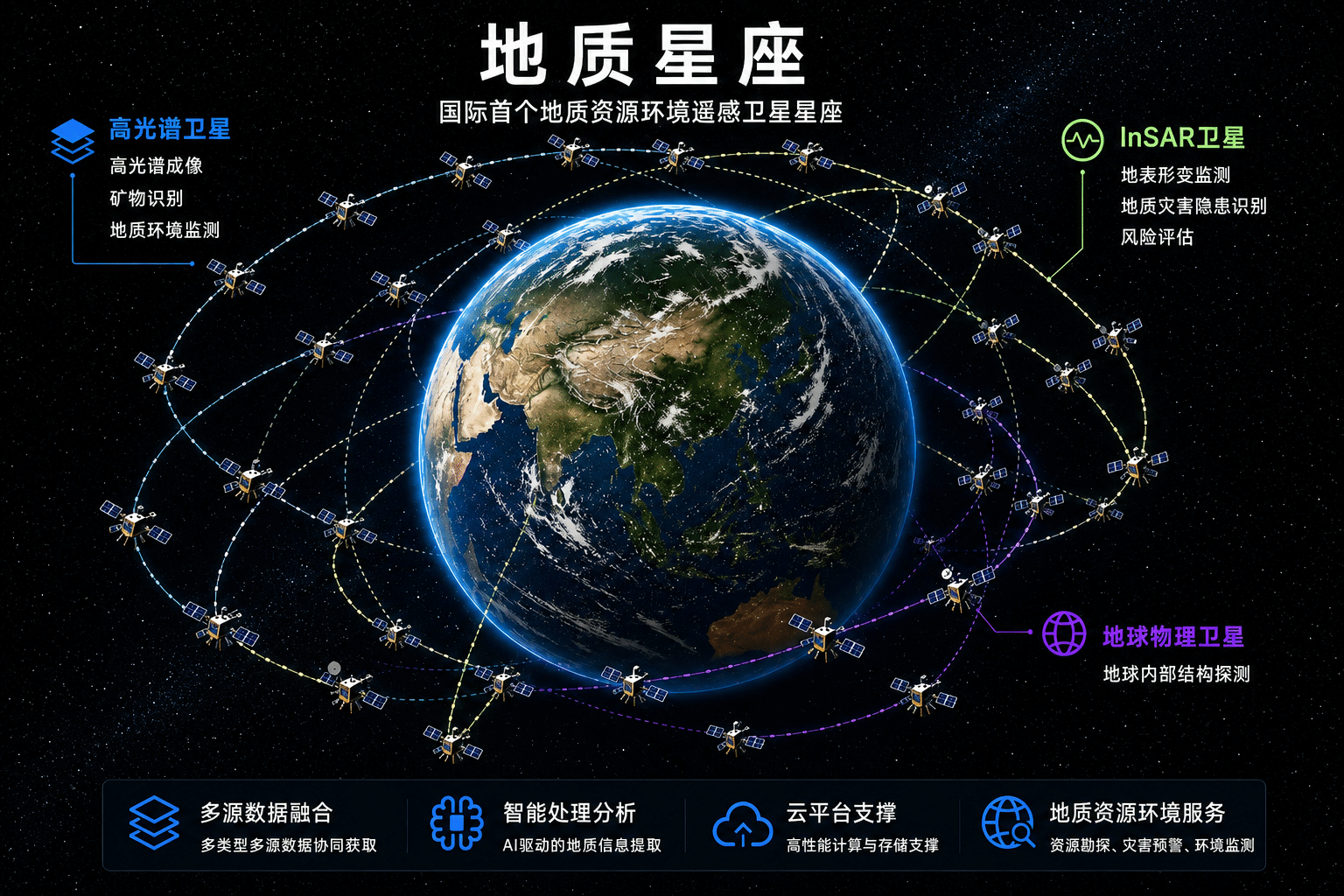
To address existing industry challenges, the newly launched Geo‑Constellation is the world’s first satellite networking system specifically focused on geological resources and environmental exploration. The constellation integrates multi-orbit satellite resources and deploys hyperspectral, synthetic aperture radar, and geophysical satellite systems across sun-synchronous orbits, medium- and low-inclination orbits, and polar low Earth orbits, thereby establishing a multidimensional, all-weather, and globally coordinated observation network.
Compared with traditional remote sensing satellites that mainly capture surface imagery, the Geo‑Constellation represents a major leap forward. It can not only precisely identify the global distribution of surface materials and monitor surface deformation with high accuracy, but also utilize low-cost, high-performance satellite networking technologies to deliver standardized and application-ready professional data products. These capabilities comprehensively support geological surveys, mineral exploration, ecological and environmental monitoring, geological disaster early warning, and many other application scenarios.
The construction of the Geo‑Constellation marks a critical step toward high-precision, low-cost, and intelligent geological resource and environmental detection technologies worldwide. This project is no longer limited to simple surface imaging collection; rather, it upgrades remote sensing technologies into a high-precision Earth measurement and intelligent service system, forming a new generation of space information infrastructure that supports national ecological civilization initiatives and global sustainable development.
Leveraging Interdisciplinary Strengths to Support Full-Chain Project Implementation
According to reports, the subsequent research and development team will continue focusing on key areas such as satellite payload development, high-performance data processing, and artificial intelligence applications in remote sensing. CUG will fully leverage its strengths in intelligent instrumentation, artificial intelligence, information processing, and other featured disciplines to deeply participate in core technology breakthroughs, intelligent model development, and frontier technological innovation, thereby comprehensively enhancing the constellation’s intelligence level and integrated application capabilities.
The Geo‑Constellation is a major achievement resulting from the interdisciplinary integration of satellite sensing technology, artificial intelligence, and Earth sciences. Relying on strong technological accumulation and cross-disciplinary research advantages, CUG will provide full-chain technical support for the project in areas including onboard satellite intelligent processing, multi-source data fusion, and intelligent data analysis. These efforts will facilitate the constellation’s large-scale and industrialized application, empower China’s mineral exploration breakthroughs, ecological protection, and disaster prevention and mitigation initiatives, and contribute Chinese technology to global geological resource and environmental governance.